
Seen from the air, the five streets that make up Oakwood Beach, New York look out of place—they are nothing more than a few spindly fingers of soil surrounded by flat estuarine wetlands. Three miles inland is Todt Hill, which, at 410 feet above sea level, is the highest point on the eastern seaboard south of Maine. Twenty-two thousand years ago, when the massive Wisconsin Ice Sheet—that covered much of New England and all New York City in mile-thick ice—retreated, it left behind certain identifiable characteristics: a long ridge of high land, known as a terminal moraine, that stretches from the southern end of Staten Island, through Brooklyn and Queens, and out the length of Long Island.
But just as glaciers can build mountains so too can they level them. As the ice sheet pulled back, much of the land close to the water subsided, creating hundreds of miles of marshes and swamps like those that surround Oakwood Beach. In other words: The slow withdrawal of the most recent ice age left much of the United States’ eastern seaboard vulnerable to sea level rise.
The United States is eleventh on the list of the countries most at risk to sea level rise, finishing just behind the canal-riddled Netherlands, deltaic Bangladesh, and the island nation of the Philippines. We are going to have to figure out what to do with our densely populated coasts, and soon, because by century’s end many of our low-lying communities will be underwater. While New York City’s response to coastal disasters has long been to build it back, after Sandy a handful of neighborhoods—like the laissez-faire, climate change denying, right-wing neighborhood of Oakwood Beach—began to experiment with larger scale solutions that most post-disaster plans scrupulously avoid. Like retreat.
There has been a tenfold increase in natural disasters since 1970 thanks, in no small part, to an increase in global temperatures. With more water sloshing around in the ocean, the devastation that coastal storms inflict has also increased. And the numbers are only expected to rise. Last summer, 40,000 square miles of ice from the Greenland Ice Sheet melted ice each day, which means that more water is being dumped into the ocean than ever before. NASA recently released a study declaring the loss of the West Antarctic Ice Sheet “unstoppable.” It alone contains enough water to raise global sea levels four feet. Coastal communities situated near or in wetlands, like those that line Staten Island’s eastern shore, are already feeling the crunch.
I heard about the end of Oakwood Beach in the spring of 2013, after a student of mine at the College of Staten Island told me that her family was trying to sell their Sandy-ruined property to the state. The storm had struck over six months earlier and many New Yorkers were still living in motels or, worse, in drafty, moldy, half demolished homes. My student’s family and her neighbors came together and launched a public campaign, begging the state to use federal money to purchase and bulldoze their low-lying neighborhoods. In February 2013, the governor agreed.
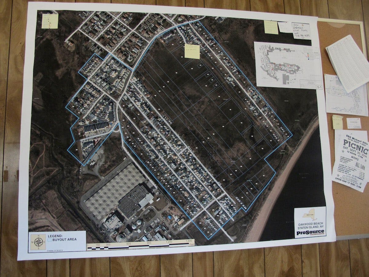
In his office at the College of Staten Island, Alan Benimoff, a professor of geology, explains to me the geologic history of the Island while the sky beyond his window threatens thunder. Pot-bellied, balding, an Italian with a big white mustache, Benimoff strikes me as an unlikely climate change aficionado; his slightly dismissive tone makes me think he is more traditional than most of his peers. While Benimoff is reluctant to talk about the future, he has no problem discussing the poorly planned urban environments that contributed to Sandy’s devastation. On his computer he pulls up a map of the island’s eastern shore compiled from various data sets, including current elevation, ownership, historic zoning and turn-of-the-century topography. Most of the land is coded red, meaning that it lies no more than ten feet above sea level. Some is shaded light blue, which is difficult to distinguish from the sea. Benimoff zooms in on Oakwood Beach. “Blue means the area is zoned as a wetland,” he explains.
Benimoff’s map also shows building footprints. After a few clicks, the map changes. “This is the turn of the century,” Benimoff explains, “you can see that the area was mostly marshland with a few buildings indicated in black.” As the century progresses the number of black dots slowly increases; the jagged lines that indicate marsh grasses are plastered over and a street grid emerges along the low-lying land next to the sea. “The area was increasingly backfilled and hardscaped. This is the problem that we are dealing with today,” Benimoff said. “Wetlands act as giant sponges, absorbing storm surges. When they are paved over, that water still has to go somewhere, crashing into everything in its path. That was a major factor contributing to Sandy’s destructive force.” Since 1900, over 90 percent of New York City’s wetlands were turned into urbanized areas through backfilling, including Oakwood Beach and its surrounding residential communities.
Benimoff looks up at me through his rimless round glasses and adds one final dataset to the map. Twenty-four red dots appear scattered along the coast. “I’ve plotted every single Sandy-related death as well. The important thing to realize is this: over half of the people who died in the storm were standing atop land that once was a marsh. If you ask me,” he says, his cursor hovering over the fragile fingers of development that comprise the easternmost reaches of Oakwood Beach, “none of those homes should have been built in the first place.”
Two weeks after Hurricane Sandy, Joseph Tirone, a boyish, fifty-year old real estate broker and longtime resident of Staten Island, made a trip to the FEMA outpost that had taken over the Jesuit retreat center at Mount Manresa. He went in seeking a small business loan to help him rebuild but left with an entirely different plan: He would attempt to get everyone in Oakwood Beach, where he owned a rental property, to agree to leave. If he could show near unanimous interest in retreat, the community would have a shot at securing funds for relocation through the Hazard Mitigation Grant Program (HMGP). The federal government would pay pre-storm prices for the homes then knock them all down so that the land might act as a buffer in the next storm. Tirone asked Oakwood Beach residents, who had congregated in a church auditorium, to discuss what kind of aid was available, where and for whom—and, if offered a fair price for their homes, who would be interested in selling and leaving? Nearly every one of the 200 people in attendance raised their hand.
“There was a palpable buzz in the crowd when those hands went up,” Tirone remembers, “because no one expected their neighbors to want to leave.” A history of municipal neglect, a future with rising seas, the pressing cost of rebuilding, and the promise of higher insurance premiums meant that many living in Oakwood Beach felt that if they stayed they would be living on borrowed time. But at first, not everyone was interested in leaving.
“One of the biggest concerns was that the land was going to be redeveloped,” Tirone remembers. “It was a lower middle class neighborhood, and everybody was pretty much at the same level of wealth, or lack of wealth. If their homes were going to be given to a rich person, or if they were going to be knocked down so that some developer could build a mansion or a luxury condo, they were not leaving,” he said. “They would stay there, they’d rot there, they’d drown there, but they were not leaving.”
An HMGP buyout, however, mandates that the land be returned to open space in perpetuity, and it was this more than anything else that convinced holdouts to participate. “I can’t tell you how many people said to me, ‘OK, you’re sure this is being returned to nature, then I will do this,’” says Tirone. Residents were willing to give up their waterfront private property—a luxury that very few could afford elsewhere in New York City—if, and only if, that property were to become a commons of sorts, the right to use held by all.
By January 2013, nearly all of Oakwood Beach had agreed to leave; they went straight to Governor Andrew Cuomo. The governor praised the community for coming together, and agreed to use HMGP funds to purchase and demolish the neighborhood. Within a year of the storm some residents were closing on the sale of their homes and starting over elsewhere.
Seeing their neighbors receive much-needed aid, residents of nearby Graham Beach, Ocean Breeze, Midwood Beach, South Beach, New Dorp Beach, Crescent Beach, Tottenville, and Great Kills all organized buyout committees of their own. “We had been trying to work with local politicians for four or five months and it was getting nowhere,” said Frank Moszcynski, director of a grassroots organization aimed at helping Staten Islanders recover from Sandy. Like so many others, he too had lost his home in the storm. Only a little more than half of the completed “Build it Back” applications had received aid in the two years since the storm. “It translates to a lot of desperation,” Moszcynski said. “The numbers are dismal,” he continued, “but what’s worse is telling people that there is nothing they can do, that they have to keep living in homes that are stripped to the studs and wait, that or they can rally for a buyout.”
Of the nine buyout committees that sprung up on Staten Island after Sandy, three—Oakwood Beach, Ocean Breeze, and Graham Beach—would successfully organize a state-managed, federal buyout. In April of last year, Barbara Brancaccio, the press representative for the Governor’s Office of Storm Recovery, said that the State had no intention of purchasing the entirety of Staten Island’s eastern shore, limiting the eligible communities to those already selected. For those left out of the buyout the only sure thing is that their homes are worth less than they were before the storm made residents and policymakers aware of the true cost of living beside a rising sea. Here on the damp fringes of what was once the most powerful city in the world, Staten Islanders are retreating from the coast because they have recognized the limits of the built environment’s ability to buffer them from a changing natural environment, and the limits of the government’s ability to buffer them from unfair and inequitable development.
Over the last decade, the National Flood Insurance Program (NFIP) has nearly gone bankrupt twice. That’s because eight out of the ten most expensive hurricanes have struck the U.S. in the last ten years. To keep the program’s head above water the NFIP is undergoing massive reform. First, the Flood Insurance Rate Maps (FIRMs) are being rewritten, which will double the number of people living in high-risk flood zones from 9 million to 18 million nationwide. If you have a mortgage and live in a high-risk flood zone, you are required by law to carry flood insurance. This is where the second phase of the reforms is targeted. The NFIP is reducing the subsidies available for policyholders in those high-risk zones. That means that owners of Staten Island’s low-lying, mortgaged, single-family homes might see their premiums rise incrementally from about $400 dollars to $5,000 dollars annually, depending on just how high above sea level their home currently sits and how much they are willing to invest in raising it. That’s a jump that will account for roughly 7 percent of the average family’s yearly income. Over the next decade, these reforms will roll out in every single flood-prone neighborhood in the United States.
In New York City, the reforms have already gone into effect. On April 1st homeowners saw the beginnings of standardized incremental policy increases. In a recent report, The Center for Catastrophic Risk Management and Compensation predicted that the rise in premiums will effectively price out many low- to middle-income homeowners. On the coasts, many of them will soon face the choice that Oakwood Beach residents considered after the storm: should they move inland?
For the communities in Staten Island that did not receive a buyout, choices are limited. If they sell they are likely to lose money. If they stay, they’ll pay more for flood insurance. They can raise their homes, rebuilding to the standards demanded by the new flood maps—which often costs more than their current claims cover but would help them reduce the price of their future flood insurance premiums. Or they can participate in the “acquisition for redevelopment” program that Borough President James Oddo is trying to get off the ground. It uses recovery funds to purchase storm-ruined properties at post-storm prices. Then the damaged homes are bulldozed and the land redeveloped in line with current flood plain regulations. Not only does the program further marginalize those who can’t afford to keep pace with flood insurance reform, the rules and regulations dictating how to safely build on the coast have a long history of being breakable, especially in New York City where real estate is a premium.
In the age of man-made climate change, rethinking the way we live is a given. But retreat is often considered a four-letter word, especially on the coasts. When people move, tax revenue disappears, property values drop, and social infrastructure fractures. Nearby communities begin to worry about repercussions for their housing markets, and their ability to pay civil servants from a smaller tax base.
Despite these very real problems Laura Tolkoff, former Senior Planner for Energy and Environment at the Regional Plan Association, thinks affected coastal communities have little choice. During a policy roundtable last year, she urged legislators to rethink their attitude toward retreat. “We need to start to have these conversations because the magnitude of the risks are growing,” she said. “There are some places in the region where we believe moving away from risk might be the best option in a set of only bad options.”
Retreat comes in two forms—managed and voluntary. Managed retreat, broadly speaking, means getting the government involved: Buildings and other infrastructure are either demolished or relocated inland and the shoreline itself is allowed to advance inward unimpeded, like what happened in Oakwood Beach. Though this is an ideal solution, there will never be enough money in federal coffers to fairly relocate everyone threatened by sea level rise—after all, that would mean abandoning Southern Florida, much of Alaska’s coast, and most of the eastern seaboard’s coastal cities.
Voluntary retreat, on the other hand, takes place when homeowners choose to sell or leave their homes without receiving financial help through government-funded programs. As a strategy, it disproportionately impacts low- and middle-income homeowners with mortgages, highlighting the ways in which poorly implemented climate change policy can and will further exacerbate this county’s growing income gaps.
Residents along the eastern shore of Staten Island blame overdevelopment for intensifying the flooding that would ultimately force them to leave. Staten Island has long been a release valve for New York City’s population crush, leaving many in “the forgotten borough” feeling taken advantage of. Jonathan Peters, an urban planning expert and economist at the College of Staten Island, calls the south and eastern shores “the wild west of city development.” Since the 1970s the City’s Board of Standards and Appeals (located in Manhattan) has granted thousands of “variances,” special waivers absolving developers from abiding from different laws regulating building construction—including a 1974 law that forbids backfilling coastal marshes—fueling the risky development practices that would come to define the island.
As we approach the three-year Sandy anniversary, it still feels as though nothing has changed. Out on Seaview Avenue in Ocean Breeze, a wetland lot abutting those that were bought by the government is currently being backfilled and developed. Backhoes are leveling the land to make way for a new string of townhouses.
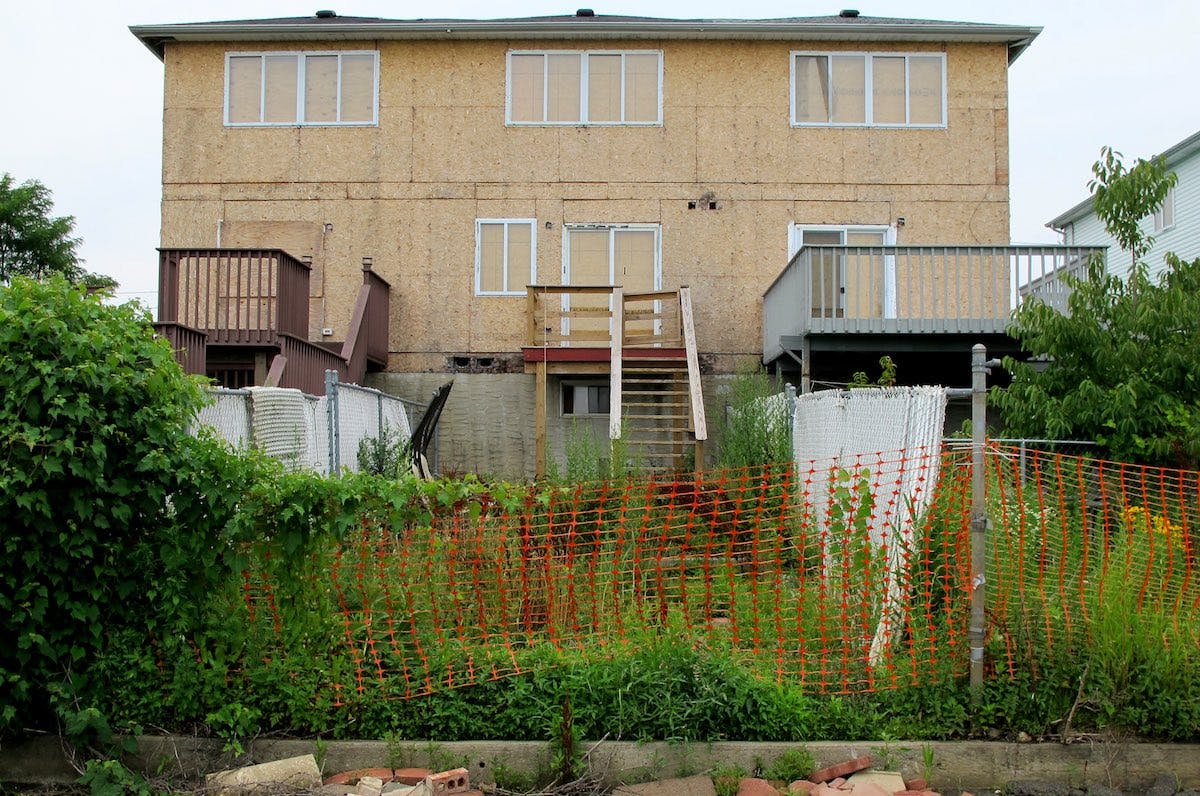
During our tour of Oakwood Beach, Tirone, the real estate broker and buyout activist, brought me to one of these planned neighborhoods at the far end of Oakwood. The two parallel streets—built directly on top of marshland—would eventually become part of the Oakwood Beach buyout area. The rowhouses were all eerily similar, with fake brick facades, cheap plastic garage doors, and matching plastic mailboxes out front. I walked out back and discovered a line of eight above ground swimming pools. Algae bloomed green and brown, and minnows darted in and out of shadows. Each pool was separated from the next by a flimsy plastic white picket fence. Like so many neighborhoods across America, it is a poorly constructed version of the American Dream, built for profit instead of longevity.
An earlier version of this story misstated that 5 percent of the Build It Back applications had been approved; the number was in fact 60 percent. Laura Tolkoff was misidentified in the story as a current policy planner for the Regional Plan Association—she is a former planner. In addition, the policy roundtable referenced occurred last December.