
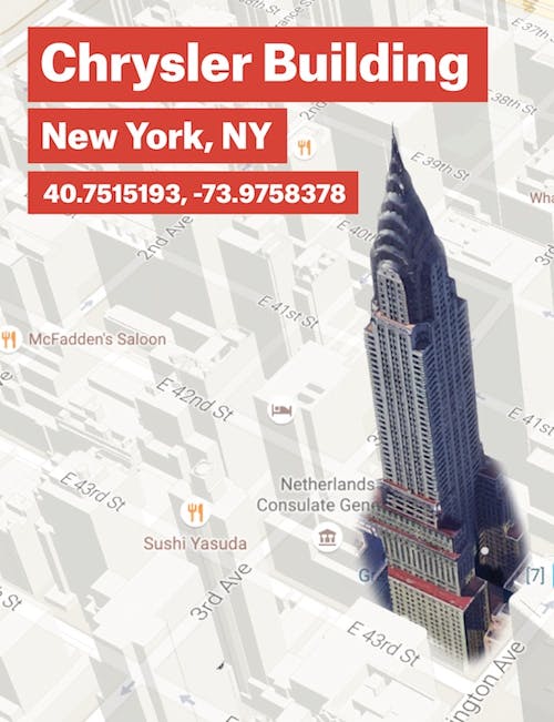
Google maps is just a set of points in space. The system of latitude and longitude is among the finest achievements of humankind. It unifies all world maps, gives them a shared language of space and distance, and allows everyone to talk about the same world. The southwest vertex of the Chrysler Building in New York City, for example, which is commonly said to be at the intersection of Lexington Avenue and East 42nd Street, is at 40.7515193, -73.9758378. Define three more latitudinal and longitudinal points, and you essentially have the shape of the building. Give those four points a name—“Chrysler Building”—and file it under “buildings” in your massive database. Gather the numbers; give them a name. Do it a billion times, and you have something.
In 2005, when Google Maps first appeared online, it arrayed the world in many such small rectangles, images that were assembled on some faraway server and shipped over the Internet to the clicking mass of users. It was not the first maps product online, but it soon became apparent that it was the best. This was a big deal—and a surprise. The Web was designed for documents. For words and pictures, or even sound files and movies—it was a system built for linking together documents across servers around the world. In early presentations, the Web’s motto was “Let’s Share What We Know!” atop a logo with three “W”s.
Google, as a search engine, had built a fine business by “indexing” all of these documents and making them searchable. The company was built on a principle of centralization: If you take the chaotic Web and bestow order upon it, merge it into a single consolidated index, make it make sense, you can make users very, very happy. And upon that index, and that shared happiness, and the willingness of some users to click on targeted advertising, Google could construct a tremendous enterprise. An empire, if you will. Except empires are not traditionally constructed from indexing documents. But maps are.
Google Maps wasn’t intended as a way to make sense of the Web. It was, instead, supposed to be a portrait of the world, the whole world. There was no text, nor any obvious links in blue. Google had used all sorts of hacks, tricks, loopholes, and backdoors so that its maps would function in a highly interactive way, to make it so that when a user moved his or her mouse, the map would go left, right, or zoom. When that happened, Google would fetch yet more and more map tiles—more rectangles—and send them down the wire. You could have as many tiles as you could consume, which is a lot. You could browse the world all day. People had been messing around with this stuff—MapQuest, anyone?—but for a company this big to undertake, it was significant.
Now, of course, every big company needs a map of its own. For example, last time I looked, Apple listed on its website 160 jobs in mapping. Imagine your new life in California as a Maps Bug Triage Engineer! Triaging maps bugs! Every day, triaging. Apple also recently purchased three whole mapping companies, Embark, HopStop, and Locationary, for satchelfuls of cash. A young and optimistic person in possession of a desire to see (if not actually visit) the world would do well to head West and get in on the digital cartography boom.
At the time, though, what Google had done felt almost like they were cheating, somehow. No company should be so good at indexing documents and images and making them searchable and also excel at creating a highly user-friendly and interactive representation of the entire world. Seeing those maps fly around the screen of a Web browser was like finding out the characters in your comic book could talk, or that your toys were actually alive.
Of course maps must be, and are, more than just a bunch of squares miraculously affixed to floating points in the electronic ether. There’s a little more to it than that. There are so many noodgy things about Earth. Notably, it is not round but rather an oblate spheroid, squashed at the poles from its relentless spinning about its axis. Its shape wasn’t settled until Louis XV sent Pierre-Louis Maupertuis to Lapland in 1736 to measure the length of a degree of an arc of the meridian. (This eventually helped cartographers solve for noodginess.) Far more recently, a “reference ellipsoid” was defined that could be used to find the center of the Earth (by mass) with incredible accuracy. That ellipsoid was called WGS84. As ellipsoids go it’s the tops. But it also means that distances between latitudes and longitudes must be calculated along the surface of an ellipsoid. Getting people to the moon was hardly a chore compared with the math involved in routing a car trip from Brooklyn to Boston.
Geography has always been one of the handmaidens of mathematics. Computers are blessedly skilled at storing and retrieving numbers. Everything else they do is an illusion brought on by their speed. But they are amazing at numbers. Computer engineers and cartographers have that in common. So if you are a massive company that is good at computers, maps are manageable. All you need is people who understand reference ellipsoids and algorithms—and people who understand how to make maps pretty.
Put those people in a room, and suddenly you have two magic powers. First, you can query the computer to find out what exists at or around a certain point on the map. Second, you can slip the computer a name like “Coney Island,” and ask it to show you what that looks like. It does so in the same manner that people once looked up phone numbers in heavy white or yellow paper collections referred to as “telephone directories.” It defines the name as a list of coordinates that the computer then uses to show the map on a screen.
That means that you can do the same thing you did with the Chrysler Building with the shape of Paris, Texas, or Pamplona, Spain. Computers are masters of repetitive tasks, and when it comes time to draw the maps, you might make every road taupe, every building gray, and draw the oceans in light blue. The key thing is that the computer does the drawing. It takes a large number of points and names and rules about colors and shapes and collates them into a single portrait. Then it turns that into a picture that it can send over the Internet.
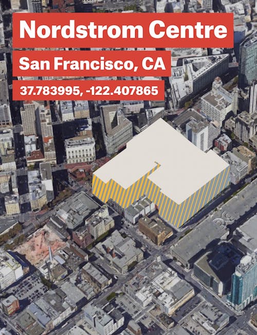
In recent years, Google Maps has become increasingly three-dimensional. The early versions were built on top of a document-delivery platform: the Web. But now the experience is far smoother. Gone is the liminal space between layers and the pauses between zooms. You just zoom in and out of the world. Amidst all the maps, layers, and views, Google has created more map than territory. Google calls this the Ground Truth project, or its effort to map the world via an “authoritative” mix of “algorithms and elbow grease.” In the hot center of San Francisco, the amount of detail on Google Maps can feel overwhelming—each floor of the Nordstrom’s on Market Street, for example, is mapped. God help us when store inventory systems are tied to this leviathan, and you’ll be able to drill down from high above the ocean to the books on the shelves at the bookstore. Except there will be no bookstores.
One thing you can do when you have Ground Truth, when you really, truly understand where things are, is make a self-driving car. You start with a set of points describing the roads, and then you turn a car into a rolling computer. It seems almost inevitable, in retrospect.
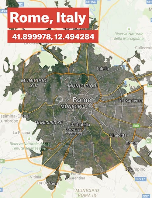
Not long before he was assassinated, Julius Caesar sent four Greek surveyors off in the cardinal directions. This was a decades-long project, so the work of mapping the world fell not to Caesar, but to a Roman statesman named Marcus Vipsanius Agrippa. The map he built was lost to history, but is believed to have been fashioned from a single rectangle of marble as large as nine feet tall. The map most likely resembled other contemporaneous maps: A labeled slice of Swiss cheese with Rome close to the center and Britannia and India at the outer edges. As a key to the empire—colonies, enemies, places of conquest—it was an absolute marvel. Pliny the Elder mentioned it in his Natural History. It symbolized the fallen Republic’s growing territorial power and influence, hinted at the global Roman dominance to come, and was a first step toward achieving it. Maps are an absolute necessity of empire.